


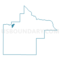
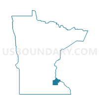
Cannon Falls W-1, Goodhue County, Minnesota
About
Outline

Summary
| Unique Area Identifier | 602045 |
| Name | Cannon Falls W-1 |
| County | Goodhue County |
| State | Minnesota |
| Area (square miles) | 2.21 |
| Land Area (square miles) | 2.18 |
| Water Area (square miles) | 0.03 |
| % of Land Area | 98.77 |
| % of Water Area | 1.23 |
| Latitude of the Internal Point | 44.50495870 |
| Longtitude of the Internal Point | -92.89402730 |
Maps

Graphs
Select a template below for downloading or customizing gragh for Cannon Falls W-1, Goodhue County, Minnesota


Neighbors
Neighoring Voting District (by Name) Neighboring Voting District on the Map
- Cannon Falls Twp. Voting District, Goodhue County, MN
- Cannon Falls W-2, Goodhue County, MN
- Stanton Twp. Voting District, Goodhue County, MN
Top 10 Neighboring County Subdivision (by Population) Neighboring County Subdivision on the Map
- Cannon Falls city, Goodhue County, MN (4,083)
- Stanton township, Goodhue County, MN (1,130)
- Cannon Falls township, Goodhue County, MN (1,070)